
Duncanville Blocks: Source Records
No single record identifies every person around an address. Start with the physical parcels, then use each source only for the fact it holds. DCAD maps show selected parcels and account detail. The appraisal record supplies owner, situs, mailing, and legal-description fields. County Official Public Records document transfers and plats. City geography layers give zoning and district context. A person lookup is not a block roster, and an association filing may identify an organization without naming members. The fastest reliable approach is a compact block record with a source note for each parcel.
| Block source | What it can show | Access |
|---|---|---|
| DCAD Digital Parcel Map | Adjacent polygons, account, legal description, map grid, and neighborhood | Free public map; boundaries are approximate |
| DCAD eSearch | Owner, situs and mailing address, values, exemptions, and account details | Free address or account search |
| Duncanville interactive maps | Zoning, districts, land use, flood, utilities, parks, and code geography | Public address or intersection map |
| Dallas County Official Public Records | Recorded owners, transfers, liens, plats, and legal descriptions | Index, copy request, or counter |
| Texas voter file | Permitted permanent or mailing-address, status, and history fields | Formal request with privacy rules |
| Citizen Access | Address-based permit, inspection, and project-role information | Portal; registration for tracking |
| Association filings and civic pages | Organization status or appointed public participants | Official filing route and city meeting pages |
Ownership and a current presence are separate questions. A mailing address can point to a tax representative, trust, or another contact. A mapped polygon may be vacant, institutional, commercial, or a common area. Keep the parcel classification and source date with each entry before drawing conclusions about a block.
Duncanville Neighbor Parcels on DCAD
The DCAD Digital Parcel Map provides the working view for nearby parcels. Search by Account/Prop Addr/Owner Name, then select an address result from the left-hand list. The map also allows searches by subdivision or condominium, survey abstract, map grid, Dallas block, and neighborhood. That range matters when the address is incomplete or when the recorded description does not use the same street wording as a current address.
Once a parcel is selected, stay centered on the map and click each neighboring polygon. Capture the account, owner, legal description, and any map-grid or neighborhood clue one parcel at a time. Use the sort arrows in a multiple-result list if needed. The DCAD parcel-map view shows the search and selection controls used for this Duncanville neighbor workflow.
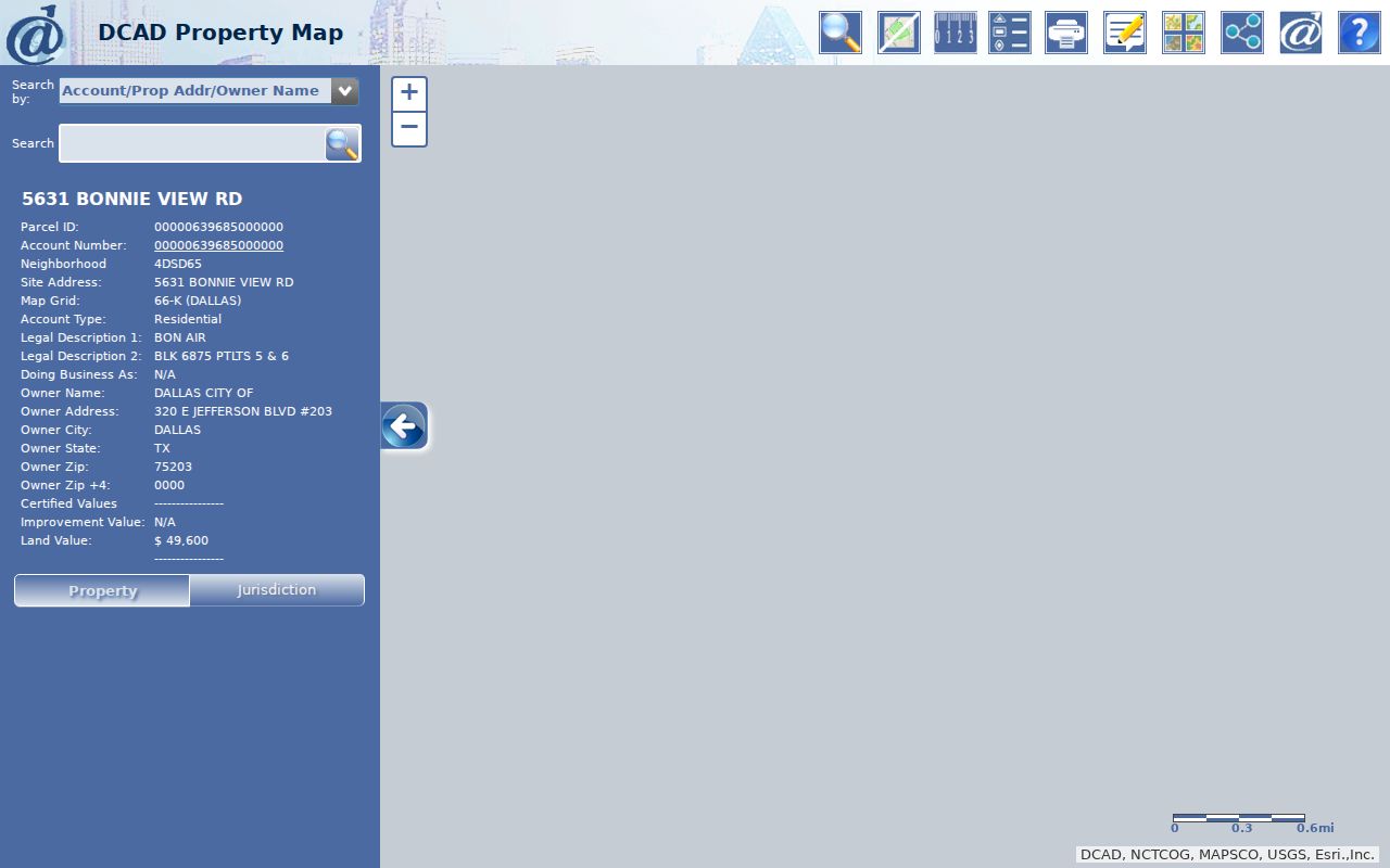
Create Property Map, Create Property Report, Share Map, and the print controls preserve the selected view. Save a map image with scale and basemap separately from the account-card detail. They answer different questions. A parcel outline is not a legal survey and does not, by itself, establish a neighbor relationship.
Duncanville Block Layers and Boundaries
Map adjacency is only a starting point. A street segment may sit near Cedar Hill, DeSoto, or an unincorporated pocket, and a Duncanville postal line is not proof of municipal jurisdiction. Compare DCAD jurisdiction fields with the City of Duncanville’s interactive map layers. Zoning, land use, flood and stormwater, council districts, parks, trails, utility systems, and code geography can explain why visually close parcels are handled by different offices.
Record whether the relevant parcel is north, south, east, west, or across a mapped right-of-way from the starting address. Then check its legal description and any subdivision or plat reference. A condominium tract, common area, park, or business parcel may look like the next door neighbor on a map but require different research. Measure Area and Measure Length can describe a custom study area, yet neither provides a legal boundary.
Note: City and DCAD maps are informational tools, so use the recorded plat or legal description when a boundary has consequences beyond ordinary neighborhood research.
Duncanville Neighbor Association Records
Association material is useful for finding an organization, not a member roll. The research identified Texas management-certificate filings for Homeowners' Association of The Meadows at Daniel Farms and Graystone Homeowner's Association LLC, both with Duncanville indicators. These filings identify association, legal, management, and ZIP information. They do not publish a list of all people on a street. The Greene HOA’s organization-hosted materials include bylaws, CC&Rs, architectural guidance, minutes, and a records-inspection policy, but no public member directory was located.
| Organization or source | Duncanville indicator | What the record provides |
|---|---|---|
| Homeowners' Association of The Meadows at Daniel Farms | Dallas County, 75137, POA | Management-certificate record, not a member list |
| Graystone Homeowner's Association LLC | Dallas County, 75116, POA amendment | Management-certificate record, not a member list |
| The Greene HOA | Duncanville organization materials | Governing documents, minutes, and records policy; no public member directory located |
| Neighborhood Vitality Commission | Citywide civic structure | Public meetings and appointed participants, not block residents |
| Community Engagement Advisory Board | City advisory board | Public meetings and minutes, not a neighborhood directory |
For current civic contacts, use the Duncanville boards and commissions page and public meeting records. Ask an association directly about its own published contact process. Do not treat an organization filing, board list, or meeting attendee list as a block directory.
Note: An association filing confirms an organization record, not authorization to obtain private contact details or meeting access.
Duncanville Block Tools Compared
Official records and commercial neighbor tools serve different purposes. Official systems show the source record and the custodian responsible for it. Third-party tools can combine property, directory, and address material, but may retain stale information or merge different people with similar names. Begin with the official record for a parcel or recorded transfer, then document what it actually says. Do not use an aggregated result to assume family ties, occupancy, or a protected address.
| Source category | Best use around a block | Key limit |
|---|---|---|
| Official parcel and appraisal records | Confirm parcel, assessed owner, situs, mailing, and legal description | Owner data is not a complete presence record |
| County recorded documents | Confirm a transfer, lien, plat, and document number | Street text may be absent; copy access can differ from index access |
| City mapping and permit systems | Understand geography and address-based project activity | Map boundaries are approximate; contacts have defined roles |
| Commercial neighbor tools | Generate a question to verify with a custodian | May mismerge, age poorly, or omit protected information |
The difference matters most on a dense block. A single parcel may have several named roles across a deed, appraisal card, permit, and association record. Preserve the role and date rather than compressing them into one unsourced label.
Duncanville Block Voter Access
A public voter-status search is not a way to browse a block. The official VoteTexas gateway and the Dallas County status route support an individual workflow whose live labels can change. The state’s formal voter-file request is different. Its layout includes permanent street components, mailing fields, ZIP, status, and election-history data, with optional county, precinct, status, and election reductions. A notarized affidavit and $75 deposit are required before the Secretary of State provides the file.
Texas Election Code §18.005 makes certain voter information public, including name, date of birth, VUID, and elections in which a person voted, not ballot choice. Protected classes can have residence or identification information withheld under §13.004, and Address Confidentiality Program participants may use substitute information. The state request form carries a noncommercial-use promise under §§18.066–.067. Do not reconstruct a household from status fields or imply a person’s party preference or vote.
Note: A status code can remain after a move, so retain the search date and do not treat it as a current address.
Map Duncanville Parcels by Address
The adjacent-parcel process keeps a block inquiry small and repeatable. It begins with one property, moves to immediately touching or facing polygons, and verifies ownership through the account and legal record. It is not a radius search and should not be used to create a broad list of people.
- Search the starting address in the DCAD parcel map. Select the correct account and note the situs address, map grid, and legal description.
- Keep the map centered, click the immediately adjacent polygons, and note direction of adjacency. Mark a right-of-way, park, common tract, or business parcel instead of treating it as a household.
- Open each selected account in DCAD eSearch to compare owner, mailing, situs, and legal-description fields. A homestead exemption can be a clue consistent with owner occupancy, but not proof.
- When a transfer needs confirmation, search the owner and legal description in the Dallas County property-record index. Preserve the instrument number and document type.
- For a full named-street chain, use the Duncanville Street Directory, which follows the address through owner, deed, voter access, and historical directory sources.
Use Share Map or Create Property Map to keep a reproducible view. The account card and map image should both retain their date and source, especially where a street crosses a jurisdiction or an address result has multiple matches.
Duncanville Block Permit Clues
Duncanville Citizen Access is the city route for permit, plan, business-license, and inspection work. The application path is Locations, Type, Contacts, More Info, Attachments, Signature, and Review and Submit. Location can be found with a map bar or a pin. The resulting record can include permit number, status, invoice or inspection workflow, scheduled time, comments, checklist material, and inspector notes. Applicant, Contractor, and Owner are defined project roles.
The Citizen Access portal shows the registration and application workflow used for an address-based city record.
Use a permit as time-bound evidence of project activity, not a current-neighbor list. Registration is required to apply or track, and public historical coverage was not located in the research. For a specific existing record that is not available through the portal, make a records request by address, date range, and record type rather than asking city staff to infer an answer.
Duncanville Community Records by the Numbers
The community layer around a block is broader than a parcel map. Duncanville’s Community Engagement Advisory Board has seven members and meets on the second Thursday, serving as a channel between residents and stakeholders. City pages also identify 17 parks, about 227 acres of parkland, and almost five miles of trails. Those figures describe civic geography, not a count of neighbors, households, or parcel owners.
City weekly updates name the Duncanville Lions Club, Rotary Club, Citizens Police Alumni, and other community organizations. Public notices can help date a meeting, project, or civic participant. No official member rosters for those groups were located. Treat public event notices as clues to public activity, then use the organization’s own contact path when a direct question is appropriate.
A useful location check pairs a parcel with a nearby park, trail, council district, or corridor shown in city maps. It adds geographic context while avoiding claims about people who live near that feature.
Duncanville Neighbor Privacy Limits
Adjacent parcel ownership is not neighbor identity. Household members, visitors, utility customers, delivery addresses, and motor-vehicle data are not public sources for a block inquiry. The federal Driver’s Privacy Protection Act restricts DMV personal information. Texas public-information law also allows confidential, sealed, juvenile, protected-victim, and sensitive personal fields to be withheld or redacted. A private compiler’s removal process cannot change a DCAD account, deed book, court file, or voter record.
The Texas Address Confidentiality Program supplies a substitute mailing address for qualifying survivors, and protected-voter guidance can limit residence data. If a record displays a substitute address or asterisks, do not try to reconstruct the address from other sources. Send correction or redaction requests to the original custodian with the record identifier and supporting proof.
Lawful use. Use Duncanville neighbor records for personal, lawful research and never to stalk, harass, intimidate, or expose a protected person. Texas Penal Code §§42.072 and 42.07 address stalking and harassment.
Duncanville Block Record Fallbacks
When a map, association filing, or permit page cannot answer a specific question, go to the custodian rather than filling gaps with assumptions. The Dallas County records hub links the County Clerk records routes. The Recording Division’s request form supports a recorded name, instrument number, document type, property address, and city, state, and ZIP. For city material, identify the address, record type, and date range. For historic address snapshots, Dallas Public Library directories and newspaper collections are the established fallback.
A written request under the Texas Public Information Act should ask for existing records, not an open-ended investigation. Name the custodian, desired format, date range, and a request for any cost estimate. Check current Dallas County service notices before travel because counter and email availability can change. This preserves a clear boundary between an official record search and an unsupported block claim.
Note: A focused request names an existing record series and date range, which gives the custodian a clear production question.