
Duncanville ZIP Code Directory Coverage
The Texas General Postal Codes manual lists three postal entries for Duncanville: 75116, 75137, and 75138. That is the documented code inventory. It is not a city-limit map, neighborhood map, or census count. The research did not locate an official delivery-unit boundary list for each code, so the table keeps unknown details marked as unknown rather than assigning neighborhoods or post-office types by guesswork.
| ZIP | Areas Covered | Post Office | Notes |
|---|---|---|---|
| 75116 | Duncanville postal area; central-city examples use this code | Duncanville-area delivery; exact station split not located | Listed in the state manual; city planning analysis uses it |
| 75137 | Duncanville postal area | Duncanville Post Office, 711 S Cedar Ridge Dr, Duncanville TX 75137-9998 | Verify each address and its four-digit ZIP+4 delivery add-on through USPS |
| 75138 | Duncanville postal code in the state manual | Exact station and delivery classification not located | Do not assume it is PO Box-only without USPS confirmation |
The documented postal-service anchor is the Duncanville post office at 711 S Cedar Ridge Drive, 972-780-1695. Its address uses 75137-9998. That station address does not prove that every Duncanville delivery address shares 75137, and it gives no basis to classify 75138 as a unique or post-office-box code.
Duncanville ZIP Code Directory Evidence
Postal geography has a local numbers wrinkle. The official state manual lists three Duncanville ZIP codes, but Duncanville’s 2025 comprehensive-plan analysis uses 75116 and 75137 as a practical city approximation. That two-code planning choice is not evidence that 75138 disappeared. It shows that a planning dataset can use a subset of postal codes for analysis, while the postal manual has a different task: listing codes associated with a place name.
The difference matters when comparing older directories, city planning material, and address lists. Keep the source label beside the code. A postal code from the manual, an address-specific USPS return, a DCAD situs city, and a city planning table may all be useful, but they do not make the same geographic claim. The address-level USPS result is the delivery check; the municipal record is the local-government check.
The numerical contrast is a useful warning for a Duncanville ZIP code directory search. Three is the documented count in the postal manual, while two is the count used by that planning analysis. Neither number identifies a neighborhood boundary, a delivery route, or a count of people. Before comparing an old address with a recent parcel record, note the date and purpose of the source. A postal label can persist while city planning, annexation, parcel, and census layers describe the same place differently.
Verify a Duncanville ZIP Code With USPS
Use the official USPS ZIP Code Lookup for a specific delivery address. Enter the street address and choose the city-and-state or ZIP path offered by the live tool. Save the returned address line, postal city, five-digit ZIP, and ZIP+4 exactly as shown. The state postal-code manual is valuable for the overall Duncanville ZIP code directory, but it cannot replace this address-level verification.
- Enter the complete street address in USPS ZIP Lookup and preserve the normalized return.
- Record the ZIP+4, postal city line, and five-digit ZIP as separate postal fields.
- Check the address in DCAD to identify the situs city, parcel account, and legal description.
- Compare the incorporated municipality with the postal result using the city map or Census geography source when a boundary question remains.
- Use the property or voter record only for the separate question it is designed to answer.
A postal city can extend beyond the incorporated city, and an incorporated Duncanville address can use a code associated with a nearby delivery route. Preserve both labels instead of changing one source to match another.
Duncanville ZIP Code Searches at DCAD
DCAD is a parcel and address tool, not a ZIP code directory. The inspected DCAD Street Address search has City but no explicit ZIP field. Its parcel map searches by address, name, or account rather than a ZIP filter. For a known delivery ZIP, first verify the address through USPS, then use DCAD’s street address and city controls to locate the parcel. A street-number range is the local way to browse a segment.
DCAD’s address-search form shows the available local fields and the absence of a public ZIP filter.
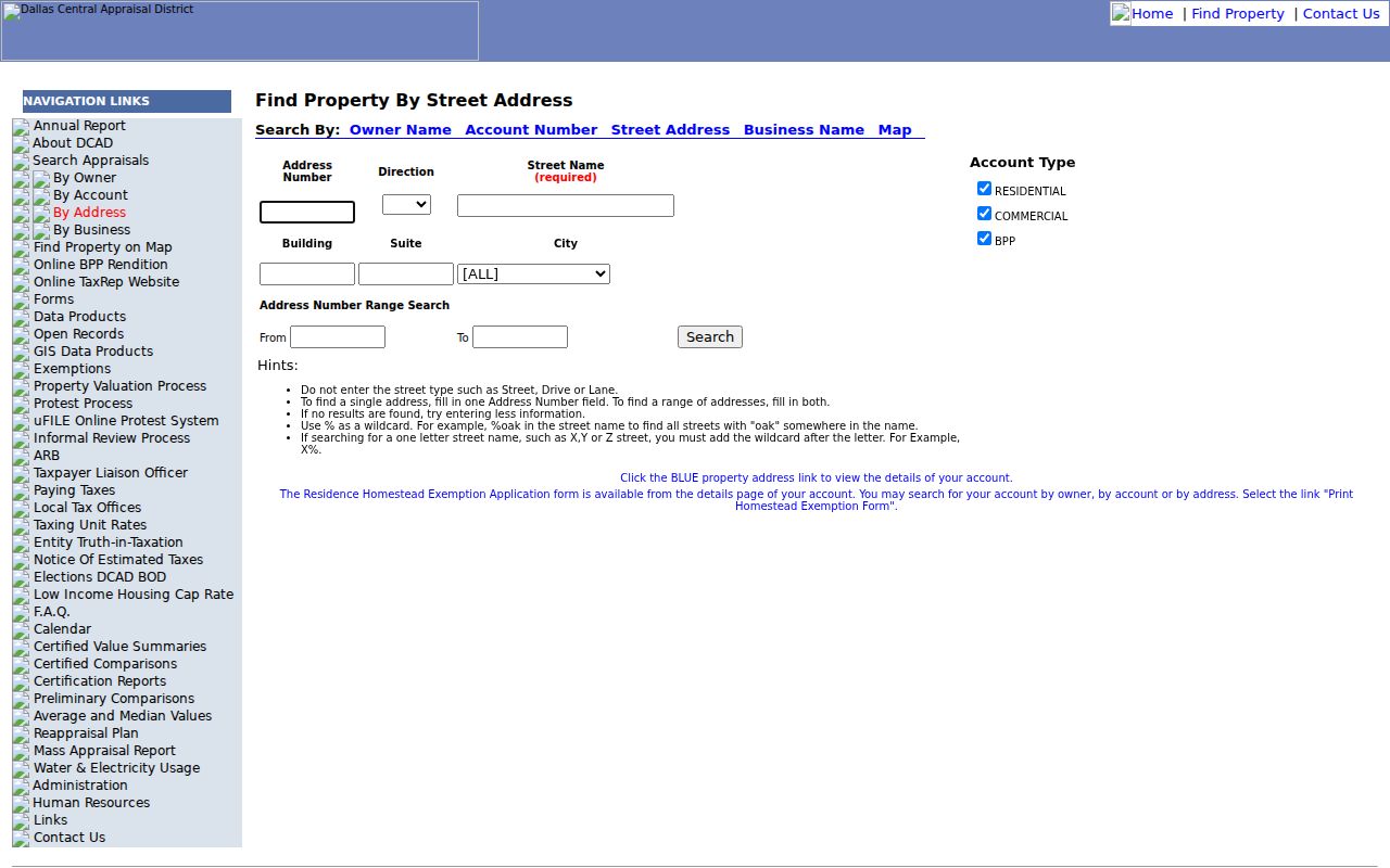
The screen uses address number, direction, street name, building, suite, and city, with From and To fields for a number range. Account Type choices include Residential, Commercial, and BPP. DCAD’s search tips say to omit the street type, use at least two street-name characters, and use a percent sign as a wildcard when appropriate. Those are address-search options, not evidence of ZIP-based search capability.
| Visible DCAD Field | ZIP-Directory Use |
|---|---|
| Address Number and Street Name | Locate a verified delivery address or narrow a street segment |
| Direction, Building, and Suite | Distinguish similar addresses where the entered address requires them |
| City | Locality control available on the form, separate from a postal ZIP |
| From and To | Browse a street-number range when a parcel question is street-based |
| ZIP code | No explicit ZIP field was visible in the inspected DCAD address form |
Once a parcel is found, DCAD can show the tax-record owner, situs and mailing address, account number, map grid, jurisdictions, and legal description. Those fields support parcel verification. They do not turn a delivery ZIP into a resident list.
Duncanville ZIP Code Fields in Voter Data
Texas voter records can contain permanent and mailing ZIP fields, but the individual voter-status check is not a ZIP roster. A statewide extract is a formal Secretary of State request product. The form provides county, precinct, election, date, age, status, and other reductions, then applies the request’s affidavit, deposit, payment, and disclosure rules. It should never be treated as a substitute for a postal address verification.
| Voter-File Field | Meaning and Limit |
|---|---|
| Permanent address and ZIP | Registration address fields, subject to protected-voter rules |
| Mailing address and ZIP | A separate contact field that may differ from the permanent address |
| County and precinct | Election administration fields, not postal-boundary labels |
| Status and effective date | Registration maintenance data, not a current household statement |
Texas Election Code limits the use and disclosure of voter information. Name, date of birth, VUID, and election participation have distinct rules, and participation does not reveal a ballot choice. A protected participant may have a substitute or withheld residence address. Respect that restriction when an address appears incomplete.
Duncanville ZIP Code Boundary Differences
A ZIP code is not a city limit. The Census explanation of ZIP Code Tabulation Areas says ZCTAs are generalized 2020 Census block polygons based on addresses and points. They can be noncontiguous, include enclaves, represent a single institution or a post-office-box geography, and do not equal USPS delivery ZIP boundaries. The research did not locate an exact Duncanville intersection list, so no street-by-street boundary claim belongs here.
For a difficult address, keep four separate entries: USPS-normalized city line, ZIP+4, DCAD situs city, and incorporated municipality. Add the county and legal description when property records are involved. A ZIP alone does not prove a voter precinct, school attendance area, tax jurisdiction, ownership, or city service eligibility.
Boundary check. When postal and municipal labels differ, retain both with their source. The mismatch is a research fact, not an error to silently correct.
Duncanville ZIP Code Definitions
Postal terms are easy to overread. The definitions below describe the type of information a field can represent, not the undocumented classification of any particular Duncanville ZIP code.
- ZIP versus ZIP+4
- The five-digit ZIP identifies a broad postal delivery area. ZIP+4 adds four digits that help USPS sort mail more precisely for an address or delivery point.
- PO Box ZIP
- A code used for post-office boxes. It must be confirmed from USPS, not inferred from a place-name list.
- Unique ZIP
- A code assigned to a single organization or large recipient. It also requires USPS confirmation before it is stated for a local code.
- Carrier route
- A postal delivery grouping used to organize service. It is not an incorporated boundary or a parcel ownership category.
Audit a Duncanville ZIP Code Result
For each address, save the original search text and the complete USPS return. Then compare DCAD’s situs address and account details without overwriting the postal line. If a parcel result does not match, try the street-name tips, directional variant, or number range in DCAD. New accounts can show a lot number until the municipality supplies a house number, so the account number, map grid, neighborhood code, subdivision, and legal description may be better continuity keys than the street text alone.
When the question becomes street-by-street, use the Duncanville street directory for the address workflow. A postal code is useful for narrowing a search area, but DCAD’s range search and the parcel’s legal description provide the more precise local record trail. For geography only, Census address tools can cross-check location but do not provide a resident roster.
Duncanville ZIP Code Directory Limits
The Duncanville ZIP code directory can identify documented postal codes and explain how to verify a particular address. It cannot supply a complete resident list. DCAD identifies tax-account information, not every person at a location. City maps are informational and approximate rather than survey products. Citizen Access is address and location first, not a public ZIP directory, and the voter route has statutory protections and request rules.
Use official sources for each question: USPS for delivery ZIP and ZIP+4, DCAD for the parcel account, and the Duncanville interactive maps for local map layers. That source-by-source approach keeps postal, parcel, and city geography from being confused.